Tuesday 24 February 2015

An Unusual Day's Caving

by Dave Ingold

Well.............an unusual day's caving! We were asked to explore ~7 caves to the north of the Cradle of Humankind in an area we haven't visited since our inception in 1954. Two caves were filled with bees and another needs rigging for rope descent. Then we found this interesting mine adit that broke into a cave. Sadly, all the pretties (stalactites, stalagmites and flowstones) had been drilled, smashed and removed in the early 1900's as is common with many of the exposed caves in the area - the calcite was a source of cement, fertiliser etc..............how great to destroy millennia of nature's creations for short-term goals? It was only a small cave but adds to our knowledge of the area and its speleology.
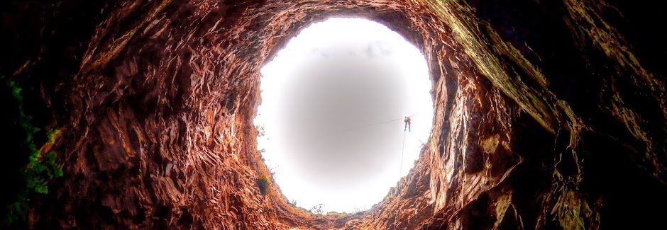
Anyway, using our new bleeding-edge survey gear we surveyed and mapped the cave to millimetre precision and will return another day to tackle the remaining caves. Apologies for the pics: It was an overcast day with a washed-out sky and, underground in SA's caves, dust is a huge problem, reflecting flash as round artifacts that look like balloons in the image. Thanks as always to my fellow cavers - this time Pete Kenyon, Gerrie Pretorius, Sharron Reynolds and Leon De Kock - I look forward to our next encounter with the underworld!


Friday 20 February 2015

Hidden Cave

An old favourite of the club was revisited on this Sunday 8th Feb. Myself, Steve Tucker and Gerrie Pretorius met five students to visit Hidden Cave. Four of the students were studying geology so they were in for a treat in this cave. Only Steve opted for the squeeze beyond the ladder drop on the return whilst the rest of us belayed down to start the descent. The stromatalite formations on the roof were noted. Steve and Gerrie went of to unsuccessfully find the Termite City and we continued the climb down, admiring the formations until finally arriving at the Waikiki dancers. They are still as interesting as ever and the same as the first time I saw them 20 years ago. The climb out found us taking a few false turns but after much huffing and puffing we were at the ladder and ready for the fresh air.

Cheers

Pete Kenyon


Tuesday 3 February 2015

Hidden Cave - 8 February

Hi everyone,

There is a trip to Hidden Cave on Sunday the 8th of February. I am hoping to find a section called Termite City and we might venture down to the Waikiki dancers and perhaps even Squeezeball if time allows. There will of course be a braai after the trip, so bring something to eat, something to drink and something to sit on.

The meeting point is the corner of the N14 and R500 (26°11'9.96"S - 27°26'27.90"E) at 08:30 and the cave is about 15minutes away from there.

Visitors are welcome to join the trip, just let me know in advance if you need any equipment. For info on what you need as a new caver go to http://www.sec-caving.co.za/p/new-cavers.html

See you Sunday,

Steven

Monday 2 February 2015

Caves

Author: Garfield Krige (SCE129)
Original article posted at: http://sterkfonteincountryestates.org.za/caves/

The residents of Sterkfontein Country Estates are very privileged. Not only do we reside in the Cradle of Humankind World Heritage Site, we also have a remarkable variety of, often rare, flora as well as interesting fauna. On top of that, forming part of a karst landscape, our area also boast some of the most beautiful caves in the country. This page is dedicated to introducing you to the wonder world of our subterranean inheritance.

The entrance to the “Big Cave” alongside Wind Gat/Virtual Reality Cave (Photo Garfield Krige)


The formation of caves in dolomite

On the web page “The Story of Malmani Road“, we explained how the sedimentary rock, dolomite, on which Sterkfontein Country Estates is located, was formed. In short, Malmani Rd is named after the Malmani Sub-Group of the Chuniespoort Group of the Transvaal Supergroup. Dolomite, named after the French Naturalist and Geologist, Déodat Gratet de Dolomieu (1750-1801), is a very special type of rock indeed. It is formed as a result of the actions of a group of ancient bacteria, the cyanobacteria, some 2.6 to 2.2 Billion years ago. For more information on where dolomite comes from, it might be worthwhile to first read “The Story of Malmani Road“, before continuing reading this page.

In the second paragraph of “The Story of Malmani Road“, we warn about the potential hazards relating to poor water management, with particular emphasis on French Drains and leaking underground pipes. Also note dolomite is susceptible to the formation of sinkholes and caves.

Over millions of years, the dolomite, just like all the other types of rocks, became fractured due to forces (movement) from within the crust of the earth. These fractures, or cracks, are referred to in geological terms as “faults“. Although dolomite is a pretty solid type of rock, these weaker fault zones in the dolomite provide access for water to penetrate deep into the rock.

Under natural conditions, rainwater is slightly acidic because of the presence of dissolved carbon dioxide. This is the result of rainwater dissolving carbon dioxide from the air through which it falls. Once on the ground, it continues dissolving carbon dioxide from the soil while seeping down to the groundwater.

When carbon dioxide dissolves in water, it forms a weak acid called carbonic acid. As its chemical name, calcium magnesium carbonate, suggests, dolomite is a carbonate-type rock (similar to limestone, just much harder). This means that dolomite is vulnerable to the dissolving power of acidic water. When the slightly acidic water seeps into the cracks and fractures in the dolomite, it will dissolve small amounts of rock. Over time, and due to the dissolution of the carbonate rock, these cracks could open up into larger cracks, allowing greater flow and gradually (and under the right conditions), the flow of water will increase and so too will the dissolving of dolomite increase. Eventually, these cracks could turn into caves.

However, due to the rate at which the water percolates through the zone above the water table (referred to as the vadose or unsaturated zone), and also as this is a slow process, most rock is dissolved only once the rainwater reaches the groundwater table. Thus, rainwater retains some of its acidity and consequential dissolving power until it reaches the groundwater table. Upon reaching this groundwater zone, the remaining acidity in the rainwater is “used up” at, and just below, the groundwater table, and significant amounts of rock is dissolved in this zone. This is also the reason that caves usually form at, or just below, the groundwater table.

Due to seasonal, and in particular, the continuous climatic changes experienced by our earth, the groundwater table is by no means stable at one elevation. It could rise and fall by several metres seasonally (summer-winter variations) and over longer periods, could rise or fall by several tens or even hundreds of metres. As an example, around 10 000 years ago, our earth was just beginning to come out of the last ice age. During this ice age, the groundwater table across most of our earth was much lower than it is today. Similarly, the sea levels were also several tens or even hundreds of metres lower due to much larger amounts of water being found in the form of ice on land. Even further back in the earth’s (more recent) history, around 40 Million years ago, the earth was almost totally ice-free! This meant that sea levels were at their highest and that groundwater tables on land were also much higher than they are at present. Interestingly, some of the offshore oil deposits found along Africa’s west coast were also formed during this time.

Fossilised fish faeces, pebbles and even a 40-million year old shark’s tooth, found 38 Km from the shore at an elevation of 42 m above sea level in Cabinda, Angola. This land was seabed 40 Million years ago, when the earth was almost entirely ice-free (Photo Garfield Krige)
Had the groundwater table not fluctuated, most of the caves would have been the same size. However, because the groundwater level continuously rises and falls, it results in caves not necessarily being thin and flat, but occasionally resulted in huge caverns.
The horizontal lines made by recent water tables, are clearly visible on the eroded dolomite rocks in this part of Koelenhof cave (Kromdraai area). The fluctuating water table resulted in a comparatively large chamber forming in this part of the cave (Photo Garfield Krige)
Over time this type of landscape will mature and more openings into caves and other underground voids could form. On the odd occasion, it could even lead to underground rivers, where a river disappears into the underground environment only to reappear some distance downstream as a flowing river on the surface of the land. Collectively this type of landscape, formed from the dissolution of soluble rocks such as limestone, dolomite, and gypsum, is referred to as Karst Topography. This type of landscape is characterized by underground drainage systems with sinkholes, dolines, and caves.
A diagrammatic presentation of a typical karst landscape
After flowing for a distance of almost 5 Km over dolomite, the Sterkwatersloop (in the northwestern part of the Cradle of Humankind) suddenly disappears into the ground. It then reappears, flowing from this spring some distance downstream – a typical feature found in a karst landscape (Photo Garfield Krige)
From research done by the University of the Witwatersrand at Sterkfontein Caves, a few kilometres east of Sterkfontein Country Estates, it is suggested that the caves in the vicinity of Cradle of Humankind (including SCE) are about 20 Million years old – that’s at least roughly when the process of cave formation began.

Once all the acidity in the rainwater is “used up” by dissolving some of the dolomite rock, the water acquires an alkaline character, as it now contains elevated amounts of calcium and magnesium carbonate in solution. The dissolved carbonate is the building block for cave formations.


Speleothems or Cave Formations

Above it was described that water percolating through the dolomite rocks would dissolve varying amounts of dolomite. The calcium carbonate dissolved in this way is described as being “sparingly soluble” in chemistry terms. This means that a small environmental change (pH, temperature, presence/absence of carbon dioxide, presence/absence of air movement through the cave, presence/absence of other substances in solution, etc.) could be all that is needed to change the calcium carbonate from a solution in water to a solid. Obviously, the rainwater percolating through the dolomite rocks above a cave would be nearly saturated with dissolved calcium carbonate. As this water reaches the air-filled chamber of a cave, the environmental conditions for the dissolved calcium carbonate would be changed ever so slightly. This usually results in the precipitation of calcium carbonate (now referred to as the mineral, calcite) and this is how speleothems are formed.

There are many forms of speleothems. The most obvious ones are dripstones (the hanging stalactites and the upright stalagmites). But there are may more types, such as flowstone, helictites, true calcium carbonate or calcium sulphate crystals and many more with less scientific names, such as spurs, rafts, curtains, fishtails, straws, etc. We have even invented our own name for a specific formation, “Bubbles”.

  • The photographs directly below serve only to illustrate some of the different cave formations and are not necessarily taken on our Estate

Stalactites (hanging from the cave ceiling) and stalagmites (growing up from the cave floor) will eventually meet to form a column. Photo taken at the Wolkberg Cave, Limpopo Province (Photo Garfield Krige)
“Bubbles” Speleothems in Koelenhof Cave, Kromdraai Area (Photo Garfield Krige)
A fish-tail formation in Koelenhof Cave, Kromdraai area (Photo Garfield Krige)

A delicate floating calcite raft in the Sterkfontein Quarry Cave, formed on the surface of a cave pool, supersaturated with calcium carbonate. Although this raft is heavier than the water on which it floats, surface tension keeps it afloat, but eventually it will sink to the bottom, joining the many other orangey-coloured rafts already there (Photo Garfield Krige)

A curtain-like formation – the result of calcium carbonate-rich water running along the ceiling of the Sterkfontein Quarry Cave. It would probably have taken millennia to form a curtain of this size! (Photo Garfield Krige)
Example of flowstone in the Sterkfontein Quarry Cave (Photo Garfield Krige)

Spurs. They are formed in seasonal cave pools where water evaporates from the pool during the dry season, concentrating the calcium carbonate to form these magnificent crystals (Photo Garfield Krige)

Crystals resembling the leaves of a fern encrusting large parts of Wind Gat Cave (Photo Garfield Krige)
Cave formations form at a comparatively (but very variable) slow rate. In our area hanging formations are formed at roughly 2.5 cm per century. However, the rate of growth could vary considerably, depending on the environmental conditions present in the cave and in the rocks above the cave.
“Baby” dripstones, about 3 cm long, that have reformed from the ceiling of a cave near our Estate. This cave was mined in the late 1800s, resulting in all calcite formations being removed. As this photograph was taken in 2006, the length of these newly formed dripstones supports the theory that cave formations grow at a rate of roughly 2.5 cm per century (Photo Garfield Krige)
There are several caves within the boundaries of SCE or in the immediate vicinity of the estate. Virtually all of these caves had been mined for their calcite during the late 1800s and early 1900s for their calcite and to make cement for the emerging gold mining industry on the Witwatersrand. This is really a pity, as many caves (and particularly their speleothems) had all but been destroyed. On the other hand, had it not been for this mining at Sterkfontein Caves, neither Mrs. Ples nor her family of Australopithecus africanus (early hominids, who lived in the SCE area between about 3.03 and 2.04 million years ago), would probably have been discovered.
The skull of “Mrs. Ples” (Plesianthropus transvaalensis) in the Transvaal Museum, Pretoria, discovered as a direct result of calcite mining at Sterkfontein Cave (Photo source Wikipedia)

A lime kiln, dating back to the late 1800s. It was used to burn calcite, mined from the caves on our estate and surrounds. The lime and cement manufactured through this process, among others, supplied in the needs of the cement- and lime-hungry emerging gold mining industry on the Witwatersrand. Mining began in the late 1800s and resumed after the Anglo-Boer War, until the price of lime dropped during the Great Depression. (Photo Garfield Krige)

The end of the line in more ways than one! Mining relics (spade and small steel railway sleepers), despondently left behind, tells the sad story of the end of an era. Additionally, the photo shows the bones of a mammal that met its end in this cave. What lies beyond this collapsed cave ceiling, nobody knows… (Photo Garfield Krige)


Fossils in Caves

Sterkfontein Country Estates falls within part of the greater Bolts Farm area. This area, centred around the actual Bolts Cave, is a zone in the dolomite where particularly many caves are found and where many fossils occur.
The Entrance to Bolts Cave on a property adjacent to our Estate (Photo Garfield Krige)
The fossils found in caves are not necessarily fossils of animals that lived in the caves, but are often the bone fragments of prey that were brought into the cave by a predator. Sometimes, however, a “whole” animal would fall down a cave entrance and the entire skeleton would become fossilised.

On the subject of fossilisation, it is well known that limestone and dolomite are good environments to preserve bones. This is simply because bone has very similar chemical properties to carbonate and thus would not be eroded by the rocks surrounding the bones. Over time, the material (bones, together with sand, stones, rocks and other material) that fell into the cave shafts built up to form talus cones, which look like giant, inverted ice-cream cones, on the cave floor. These deposits are subsequently cemented into a concrete-like substance, by the lime-rich water to form a type of rock called breccia. Bones within these talus cones are mineralised by calcium carbonate within the breccia.

Breccia forms when sand, gravel and stones, sometimes also containing bones, fall down an opening into a cave. It is then cemented together into a concrete-like substance by calcite-rich water (Photo Garfield Krige)

Bones and mammal’s teeth in the breccia of a cave adjacent to our Estate (Photo Garfield Krige)

Bones of a large animal embedded in this breccia in a cave near our estate (Photo Garfield Krige)

It is rather unusual to find the fossilised remains of a land snail (Photo Garfield Krige)

A fossilised vertebra, together with some cave formations were captured in this mass of breccia in a cave adjacent to our Estate (Photo Garfield Krige)
The two important caves on our Estate are protected against vandalism and are in safe hands, thanks to the conservation consciousness of the landowners Louis Trichardt and André Grové, on which Wind Gat (also known as Virtual Reality), and Knocking Shop Caves are located.

Fortunately, neither of these caves were mined during the gold rush era. When looking at the photographs below, it will become clear that these caves are not suitable for commercial exploitation in any way whatsoever (even if permission could be obtained from the authorities to do so - something virtually impossible!). The caves themselves are just too delicate and both caves’ entrances and passages are too narrow for the “average” tourist.

Furthermore, these caves also happen to be two of the most spectacular caves found in this vicinity, boasting absolutely unique cave formations. Although our caves are not of the huge cavernous type such as Wonder Cave, or to a lesser degree, Sterkfontein Cave, our caves boast the most unique and fragile speleothems imaginable.

So join us in a photographic journey of this subterranean wonder world!


Wind Gat/Virtual Reality Cave

This cave has two different names, depending on whom you talk with.

If you talk to the landowner (Louis) or the author (Garfield), it will be named “Wind Gat” (the Afrikaans for “wind hole”). This name was derived from the strong air movement into and out of the small entrance of the cave. Such air movement suggests that this cave is connected to a large underground void. Most likely, there is still a lot of cave to be explored!

However, members of the Speleological Association of South Africa (SASA) would most likely refer to it as the “Virtual Reality Cave”, simply because it has the most breathtaking cave formations imaginable. Either way, have a look at the photos below. This cave is simply stunning!

All but one of the Wind Gat Cave photographs by Garfield Krige

Not for the feint-hearted! After getting through the first entrance, you must worm yourself down this 12-m deep vertical chimney to actually get into the Wind Gat Cave. Getting out is orders of magnitude worse!

Great fishtail formations in Wind Gat Cave (Photo Louis Trichardt)

These thin straw formations in Wind Gat Cave, are the hosts for a myriad of helictites growing in manners that seemingly defy gravity

Wind Gat Cave does not have bare walls. Everywhere the walls and other formations are encrusted with these fern-like calcite crystals

Flowstone formations in Wind Gat Cave (and the photographer’s torch)

Fishtail formations in Wind Gat Cave

This stalactite has formed an almost animal-like looking sculpture!

Cave curtains draping from the ceiling of Wind Gat Cave

Like many others, this straw formation in Wind Gat Cave has helictites growing from it

A mass of helictites glistening in the light of the camera’s flash in one of the chambers of Wind Gat Cave

These stalactites and straw formations in Wind Gat Cave are hosts for a myriad of helictites growing in manners that seemingly defy gravity

Helictites, growing from a crystal-encrusted wall in Wind Gat Cave, demonstrate that gravity has no role to play in the direction in which they grow

Stalactites, straw formations, curtains, flowstone, calcite crystals and helictites. There is just not enough space for all the speleothems in this part of Wind Gat Cave!

Louis enjoying the splendor of Wind Gat Cave

This picture in a corner of Wind Gat Cave tells it all! What more can you expect from a cave?

Eventually all good things come to an end. Here the last caver emerges from the entrance of Wind Gat Cave. This is the entrance that blows almost constantly and which gave this cave one of its two names (“Wind Gat” = “Wind Hole”)


Knocking Shop Cave

Apparently this cave was named “Knocking Shop” because of all the hammering necessary to breach the initial entrance many years ago when it was first discovered. We heard a different story, but will stick to this explanation!

The “fossil” himself, Dave Ingold, who provided most of the photographs of the Knocking Shop Cave used on this page

Beautiful cave formations in the Knocking Shop Cave

Like little gnomes hiding behind a calcite formation, these younger, white, stalagmites in the Knocking Shop Cave, contrast with the older orange-coloured formations around them. This discolouration is caused by iron oxide forming in the water when air enters the cave

The cave formations in the Knocking Shop Cave rival those of Wind Gat Cave, a mere 900 m away

Calcite “icicles” in the Knocking Shop Cave

Calcite “icicles” forming an archway, Knocking Shop Cave

Another beautiful calcite formation, Knocking Shop Cave

A speleologist in awe of the beauty surrounding her in the Knocking Shop Cave

A filigree of helictite-encrusted stalactites, Knocking Shop Cave

A speleologist in awe of the “ceiling decorations” at the Knocking Shop Cave


Acknowledgements

Dave Ingold (who supplied photos of the Knocking Shop Cave and other assistance regarding caving) of Speleological Exploration Club (www.sec-caving.co.za), a founder member of the South African Speleological Association (SASA); Neil Norquoy of Wild Cave Adventures (www.wildcaves.co.za) who accompanied the author on many of the caving expeditions; Louis Trichardt (a SCE resident) and André Grové, a speleologist (www.caves.co.za)


  • About the author: Garfield Krige was a contributing author of the Water Research Commission publication, ‘The Karst System of the Cradle of Humankind World Heritage Site‘ – WRC Report No. KV241/10 (May 2010)